


(TheNewswire)

-
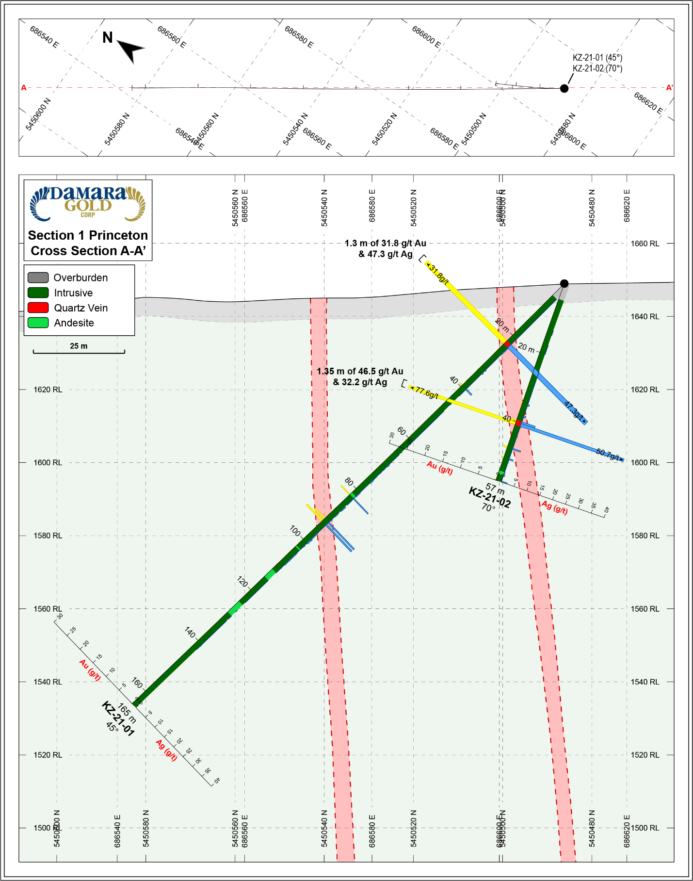
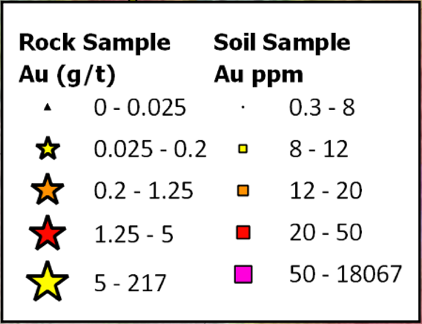
KZ-21-01 intersected 1.30 meters at 31.80 g/t gold and 47.3 g/t silver
-
KZ-21-02 intersected 1.35 meters at 46.51 g/t gold and 32.2 g/t silver
-
KZ-21-05 intersected 3.00 meters at 39.20 g/t gold and 80.4 g/t silver (previously released)
-
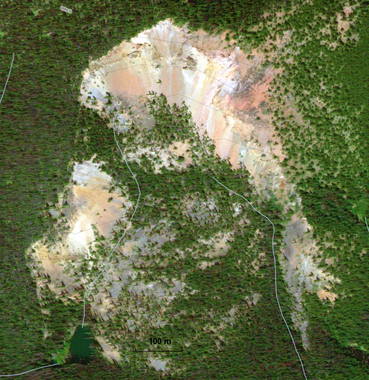
Kodiak Zone is still open in all directions, within a largely untested 1.5 km long and 600 meter wide high-grade soil anomaly open to the east
-
To date only 200 meters of the 600 meter wide soil anomaly have been tested; Excellent potential for additional parallel veins below select high-grade float samples1
-
8,563 hectares of additional ground acquired along strike in both directions; brings total consolidated land position in the Copper Mountain district up to 17,519 hectares
-
New colour anomalies identified, appear stronger than Kodiak zone gossan, presenting strong geochemical targets for additional high-grade gold zones
The full PDF news release with high-resolution figures has been posted to the Company’s website at the following link: https://www.damaragoldcorp.com/2022-news.html
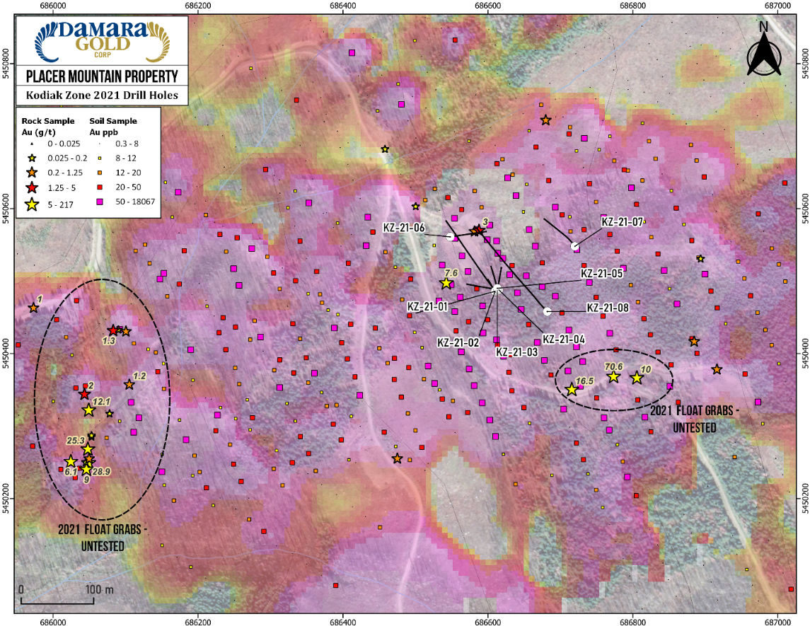
April 7, 2022 – TheNewswire - DAMARA GOLD CORP. (TSXV:DMR) (“Damara” or the “Company”) is pleased to announce more high-grade assays from its orogenic-style Kodiak Zone discovery on the Company’s Placer Mountain project in Southern BC (“Placer Mountain” or the “Property”). The mineralization is characterized by quartz-sulphide veining with clay-sericite alteration halos, hosted within intrusive rock near to the contact with Nicola Group volcanic and sedimentary rocks. Quartz-sulphide veining was intersected in all holes, and the system remains open in all directions. Only a small portion of the large gold in soil anomaly was drill tested in Phase I (Figure 1). The south-eastern half of the surface geochemical anomaly where several high-grade select grab samples1 up to 70.6 g/t gold were collected last summer, has not yet been tested. The overall soil anomaly strikes for 1.5 kilometers east-west and trends under post-mineral volcanic cover to the east.
Table 1 - Select Intercepts from Remaining 2021 Drill Holes
|
Hole ID |
From (m) |
To (m) |
Interval (m)2 |
Au (g/t) |
Ag (g/t) |
|
KZ-21-01 |
22.10 |
23.40 |
1.3 |
31.80 |
47.3 |
|
AND |
82.25 |
82.55 |
0.3 |
3.30 |
7.7 |
|
AND |
91.70 |
93.00 |
1.3 |
3.21 |
8.9 |
|
KZ-21-02 |
39.55 |
40.90 |
1.35 |
46.51 |
32.2 |
|
AND |
47.25 |
47.60 |
0.35 |
1.04 |
3.1 |
|
KZ-21-03 |
32.25 |
32.55 |
0.3 |
0.53 |
2.1 |
|
KZ-21-04 |
35.70 |
36.00 |
0.3 |
1.46 |
5.9 |
|
KZ-21-05* |
27.00 |
30.00 |
3.0 |
39.2 |
80.4 |
|
KZ-21-06 |
21.00 |
22.05 |
1.05 |
0.96 |
8.4 |
|
KZ-21-07 |
64.65 |
64.95 |
0.3 |
1.11 |
2.3 |
|
KZ-21-08 |
45.40 |
45.80 |
0.4 |
17.40 |
77.5 |
|
AND |
84.10 |
122.05 |
37.95 |
0.28 |
0.9 |
|
AND |
139.35 |
150.25 |
10.9 |
0.23 |
0.8 |
|
MV-21-07 |
86.80 |
87.30 |
0.5 |
8.92 |
28.5 |
|
AND |
106.90 |
107.40 |
0.5 |
1.81 |
17.9 |
|
MV-21-08 |
86.20 |
86.50 |
0.3 |
3.69 |
33.6 |
|
AND |
88.00 |
89.30 |
1.3 |
1.36 |
4.5 |
|
MV-21-09 |
76.40 |
77.00 |
0.6 |
3.29 |
3.6 |
*KZ-21-05 previously released – See News Release dated March 24, 2022
CEO Comment
Larry Nagy, CEO, commented “We are pleased to continue intersecting high-grade gold and silver veining at the Kodiak Zone. The snow is melting rapidly and our crews are gearing up for another productive season of exploration at Placer Mountain. Due to the successful drilling results, we decided to expand our land position even further along strike in both directions, and added several new targets identified from the analysis of satellite imagery. Field evaluation of these targets will begin soon. Our modern systematic approach to exploration has been very successful at generating new targets which are returning very strong drill results. It is exciting to be generating new orogenic gold discoveries so close to the producing Copper Mountain Mine in Southern BC. We look forward to further extending our currently defined mineralization with drilling this summer as we work toward our ultimate goal of defining a future mineral resource at Placer Mountain.”
Click Image To View Full Size
Figure 1 – Plan Map of 2021 Drill Holes at Kodiak Zone

Click Image To View Full Size
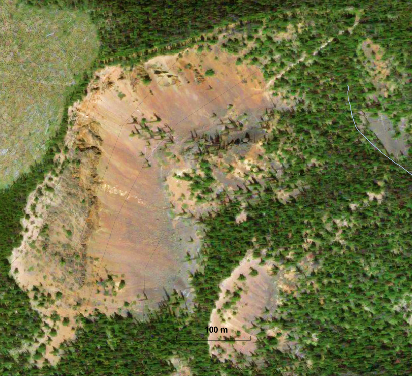
Figure 2 – Plan Map of 2021 Drill Holes at Kodiak Zone
Click Image To View Full Size
Figure 3 – Cross-Section of Drill Holes KZ-21-01 and KZ-21-02
Further Land Consolidation
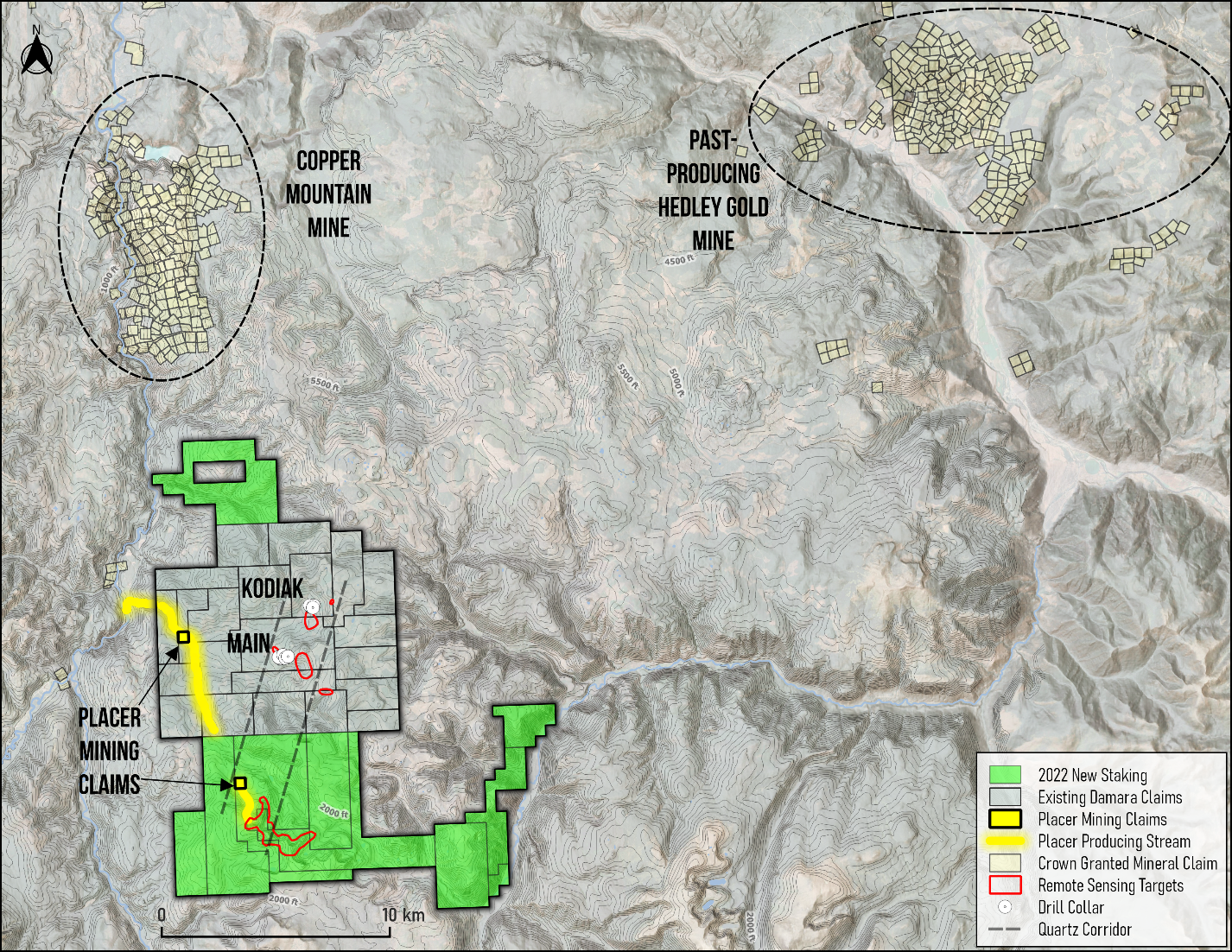
The Company is also pleased to announce it has staked 8,563 hectares of additional ground along strike of the Placer Mountain gold system, bringing the total land position to 17,519 hectares (Figure 4). The ground was acquired via direct staking by the Company when it became available on January 1 and April 1, 2022. Mapping by the Company last Summer, as well as airborne geophysical surveys have helped to refine the precise location of the important intrusive-volcanic contact, and the trend of high-grade gold mineralization intersected at the Main Zone and the Kodiak Zone.
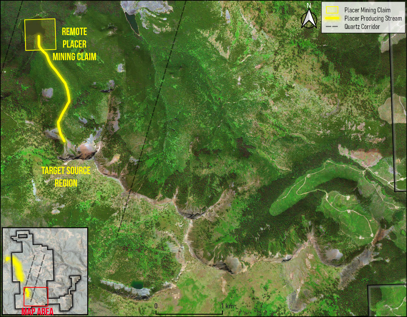
The new claims adjoining the south end of the Property overlap a placer mining claim not owned by the Company, which indicate a potential placer gold bearing stream and bedrock source region to the south, within the Company’s new ground (Figure 5). This placer claim and another within Placer Creek to the north overlap the Company’s bedrock mineral rights.
Click Image To View Full Size
Figure 4 – New staking by the Company as of April 1, 2022, covering satellite colour anomalies and overlapping competitor placer mining claims
Click Image To View Full Size
Figure 5 – 1:25,000 map showing overlapping competitor placer mining claim and possible source region of interest in new 2022 claims
Satellite images reveal an east-west trending series of gossanous colour anomalies, exposing strongly iron oxide altered bedrock (Figures 6,7). The colour anomalies are similar but far stronger in appearance to that utilized in the initial discovery of the Kodiak Zone (Figure 8). According to the British Columbia MEMPR Assessment Report Database, the area has had no previous exploration. An aggressive regional geochemical survey is planned to cover this large and encouraging target area, which is composed of a series of colour anomalies lying along a straight line trend spanning over 9 km within Damara’s ground. Examples of just two of the new anomalies acquired by staking are shown in Figures 6 and 7.
Click Image To View Full Size
Figure 6 – Satellite image of a strong iron oxide and altered bedrock colour anomaly within the Company’s newly acquired land package
Click Image To View Full Size
Figure 7 – Satellite image of a second iron oxide colour anomaly within the newly acquired land package
Click Image To View Full Size
Figure 8 – Satellite image of the iron oxide anomaly which led to the discovery of the Kodiak Zone
Deposit Model
The Company has noted strong preliminary similarities to the drilling pattern at Gold Mountain Mining Corp’s. Elk Deposit3, which recently began commercial production on an orogenic gold system just 76 km to the north of Placer Mountain. The Elk Gold Deposits, which are defined by approximately 50,000 meters of drilling in 973 drill holes, are centered along the contact between Nicola Group volcanic and sedimentary rocks with a Jurassic aged intrusion. Both the Main Zone and the newly discovered Kodiak Zone at Placer Mountain are located along a similar geological contact, which represents an important structural control and guide to the Company’s future exploration.
Near Surface Oxidation
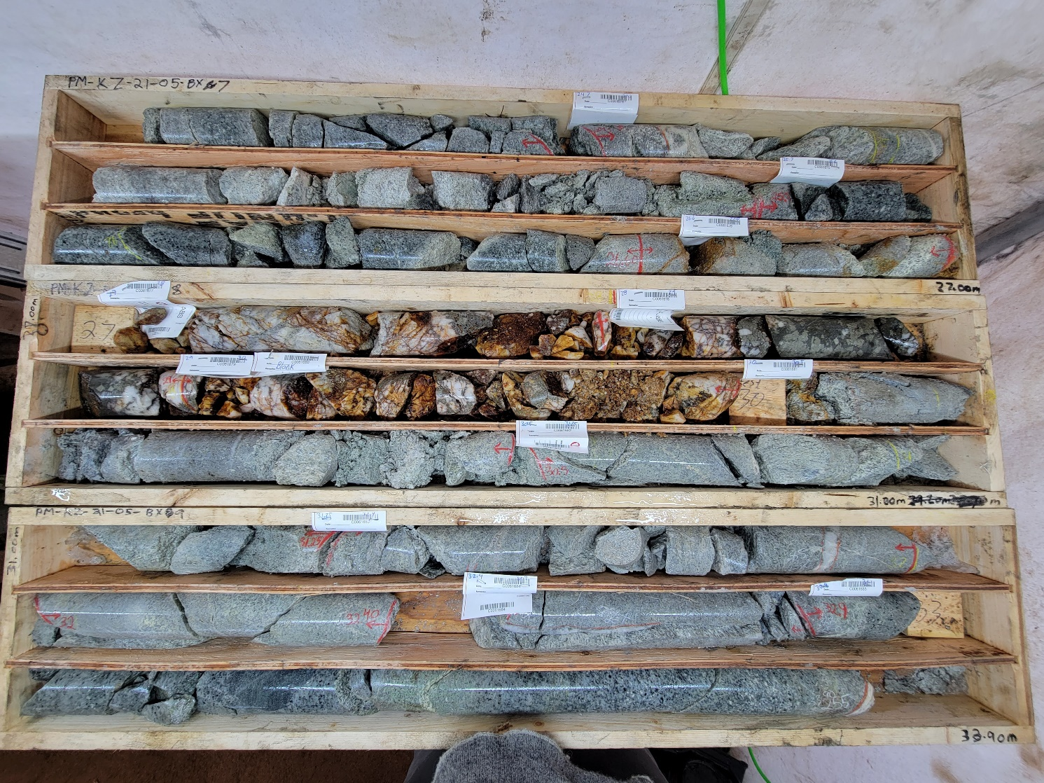
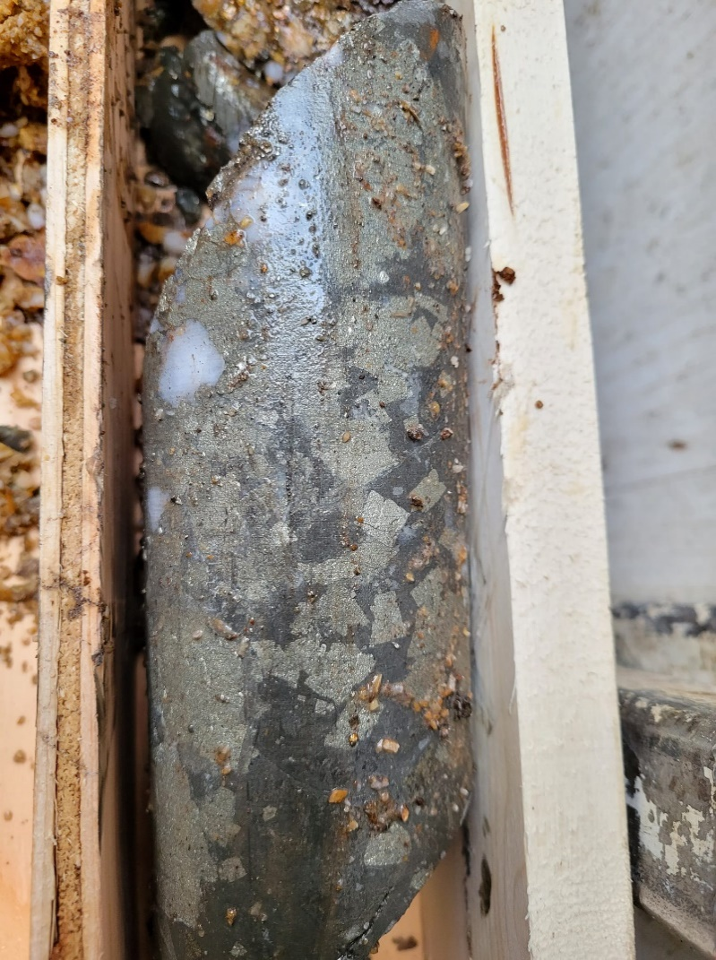
Sulphide mineralization within the veins is strongly oxidized and weathered in the near surface, which results in low core recovery in the mineralized veins and suggests that the high-pressure water used in the diamond drilling process may be washing out some of the fine gold hosted in the soft, friable oxide minerals such as limonite. For example, in KZ-21-05, from 27 – 30 meters, core recovery was 65% (Figure 9). The strongly resistant pieces of quartz were recovered, but it is possible that some of the soft oxidized and fine-grained sulphide minerals which host the gold may have been washed-out by the diamond drilling process. The strongest gold grades in KZ-21-05 are associated with a relatively rare occurrence of unoxidized sulphide mineralization in the near surface from 28-29 meters (Figure 10). The unoxidized sulphide mineralization, which was not washed out by the diamond drilling process returned 87.5 g/t gold and 169 g/t silver (Figures 10,11).
To improve recoveries of the fine oxidized minerals which may host some of the gold mineralization, the Company is considering implementing reverse circulation (RC) drill rigs for the shallow drilling going forward, as RC drills effectively vacuum the fine cuttings up the centre of the drill string and would likely improve the recovery of the fine gold-bearing oxide minerals at Placer Mountain. Core drilling will still be utilized for deeper drilling below the oxide interface, where better core recoveries can be anticipated.
Click Image To View Full Size
Figure 9 – Poor HQ size core recovery in strongly oxidized vein from KZ-21-05

Click Image To View Full Size
Figure 10 – Close-up of unoxidized sulphide mineralization from Figure 4 grading 87.5 g/t gold and 169 g/t silver from 28-29 meters in KZ-21-05
Click Image To View Full Size
Figure 11 – Close-up of competent “stick rock” in Figure 5, not washed out by core drilling, grading 87.5 g/t gold and 169 g/t silver from 28-29 meters in KZ-21-05
2022 Exploration Program
The Company is currently consolidating it’s 2022 exploration plans for Placer Mountain, which will be focused on further drilling of this orogenic gold system at depth and along strike at both the Main Zone and the Kodiak Zone. The program will also include extensive soil sampling and geologic field investigations, both on its existing claims, as well as on the larger regional land package recently acquired.
QA/QC Procedures
Drill core samples were prepared and analyzed at MSA Labs laboratory in Langley, B.C. by analytical code AuAg12, which assays gold by fire assay and silver by aqua regia digest. Prior to shipment, blind quality control samples were inserted at a frequency of 1 in every 10 samples, including blank material, 3 different certified reference standards (high, medium and low grade gold and silver), ¼ core duplicates and empty bags for pulp duplicates. Sample preparation at the laboratory was completed by crushing the entire sample to 70% passing -2mm, riffle splitting off 1 kilogram and pulverizing the split to greater than 85% passing 75 microns. Using a 30 gram sub-sample, the gold values are determined by fire assay method, with atomic absorption finish, which reports results in parts per million (ppm) (equivalent to grams per tonne (g/t)). Silver results were determined by aqua regia digestion with ICP-ES finish. Analytical results for the quality control samples were independently verified to pass.
Qualified Person
Dr. Gerald G. Carlson, PhD, PEng, technical advisor to the Company, is the Qualified Person as defined by National Instrument 43-101 who has reviewed and approved the technical data in this report.
About Damara
Damara Gold Corp. is a TSX Venture listed Canadian public company with a Board of Directors seasoned in the mineral exploration industry and having extensive and successful international experience with a focus on identifying and acquiring prospective and under-explored gold properties worldwide.
ON BEHALF OF THE BOARD OF DIRECTORS OF DAMARA
“Larry Nagy”
Larry Nagy, Chief Executive Officer
For additional information visit Damara’s website at www.damaragoldcorp.com or contact:
Damara Gold Corp.
Larry Nagy
Chief Executive Officer
Ph: (250-717-1840)
Disclaimer for Forward-Looking Information
This news release contains statements that constitute "forward-looking Information", as such term is used in applicable Canadian securities laws. Such forward-looking information involves known and unknown risks, uncertainties and other factors that may cause the Company’s actual results, performance or achievements, or developments in the industry to differ materially from the anticipated results, performance or achievements expressed or implied by such forward-looking information. Forward-looking information includes statements that are not historical facts and are generally, but not always, identified by the words "expects," "plans," "anticipates," "believes," "intends," "estimates," "projects," "potential" and similar expressions, or that events or conditions "will," "would," "may," "could" or "should" occur.
Although the Company believes the forward-looking information contained in this news release is reasonable based on information available on the date hereof, by its nature forward-looking information involves assumptions and known and unknown risks, uncertainties and other factors which may cause our actual results, level of activity, performance or achievements, or other future events, to be materially different from any future results, performance or achievements expressed or implied by such forward-looking information.
Examples of such assumptions, risks and uncertainties include, without limitation, assumptions, risks and uncertainties associated with general economic conditions; the Covid-19 pandemic; adverse industry events; the receipt of required regulatory approvals and the timing of such approvals; that the Company maintains good relationships with the communities in which it operates or proposes to operate, future legislative and regulatory developments in the mining sector; the Company’s ability to access sufficient capital from internal and external sources, and/or inability to access sufficient capital on favorable terms; mining industry and markets in Canada and generally; the ability of the Company to implement its business strategies; competition; the risk that any of the assumptions prove not to be valid or reliable, which could result in delays, or cessation in planned work, risks associated with the interpretation of data, the geology, grade and continuity of mineral deposits, the possibility that results will not be consistent with the Company’s expectations, as well as other assumptions risks and uncertainties applicable to mineral exploration and development activities and to the Company, including as set forth in the Company’s public disclosure documents filed on the SEDAR website at www.sedar.com.
THE FORWARD-LOOKING INFORMATION CONTAINED IN THIS PRESS RELEASE REPRESENTS THE EXPECTATIONS OF DAMARA AS OF THE DATE OF THIS PRESS RELEASE AND, ACCORDINGLY, IS SUBJECT TO CHANGE AFTER SUCH DATE. READERS SHOULD NOT PLACE UNDUE IMPORTANCE ON FORWARD-LOOKING INFORMATION AND SHOULD NOT RELY UPON THIS INFORMATION AS OF ANY OTHER DATE. WHILE DAMARA MAY ELECT TO, IT DOES NOT UNDERTAKE TO UPDATE THIS INFORMATION AT ANY PARTICULAR TIME EXCEPT AS REQUIRED IN ACCORDANCE WITH APPLICABLE LAWS.
Neither the TSX Venture Exchange nor its Regulation Services Provider (as that term is defined in the policies of the TSX Venture Exchange) accepts responsibility for the adequacy or accuracy of this press release.
1 the reader is cautioned that rock grab samples and their respective photographs are selective by nature and may not represent the true grade or style of mineralization across the Property
2 The intervals reported in these tables represent drill intercepts and insufficient data are available at this time to state the true thickness of the mineralized intervals. All gold values are uncut.
3This news release contains information about adjacent properties on which Damara has no right to explore or mine. Readers are cautioned that mineral deposits on adjacent properties are not indicative of mineral deposits on the Company’s properties
Copyright (c) 2022 TheNewswire - All rights reserved.
